
Courtesy of the Jowett Car Club of New Zealand, South Island Branch.
Hanmer to Waiau and return
As usual, follow all road rules and do not hold up other traffic.
- Starting in Harrogate Street, Hanmer Springs, bringing a picnic lunch to be taken in Waiau, where hot water and toilets will be available in the Hall and an adjacent cafe caters for last-minute needs.
- Depart the motel turning left on Harrogate Street.
- Turn left onto Amuri Avenue.
- Continue as this becomes Hanmer Springs Road.
- Cross Percival River. (Some may know of a lookout point further ahead, on the the right opposite “Riverview” as you climb to cross the Waiau Ferry Bridge; the entry is risky from this direction so please do not attempt it today; we will view the bridge and gorge from the other side using a safe entry.)
- Crossing the plain of the Hanmer Basin, ahead and to your left the Amuri Range rises steeply, uplifted along the Hope Fault (where the foothills of the Seaward Kaikoura Range were uplifted); to your right, beyond the Waiau Gorge, the Hope Fault uplifts the Tekoa, Organ and Crawford Ranges.
The Hope Fault
One of the South Island’s major faults, the Hope Fault begins in the south west near Inchbonnie, on the Alpine Fault, and runs north east for some 85 miles before plunging offshore near Rakautara, into the Hikurangi Trough. The Hope Fault not only uplifts mountains – it also moves them sideways. Lateral movement along such a fault is termed “transcurrent’ and in this case the movement is “right lateral” or “dextral” – were you standing on one side of the Hope Fault in an earthquake looking across the fault, the other side would move to your right. In the Hanmer region the Hope Fault has split, one segment continues along the north side of the basin, the other runs along the south side; one effect of this particular sideways step of the fault is to drop the floor of the basin, allowing it to be infilled with gravel and sand; another is to create the situation for forming a gorge (the Waiau Gorge, ahead of us).
Immediately west of the Hanmer Basin, the Lewis Pass Road SH7 runs along the Hope Fault, and this highway passes in front of the well-known Glynn Wye Station. The fault zone is shown in many fractured and crushed greywacke roadside outcrops, and some of the road bridges are on the line of the fault; these will suffer at some stage.
If you were to follow this section of SH7 to the west you could observe the following: Immediately after crossing Manuka Creek the road bends left and enters a small gentle gully occupied by a swamp and sag ponds on your left, on the fault trace; the road then climbs gently to crest a rise with a larger, horseshoe shaped pond (again on the fault trace) to your left; downhill, ahead lies the Glynn Wye station, also on the fault trace. This gully, the swamp and ponds are formed along the Hope Fault and here in 1888, a piece of geological history was made when geologist Alexander McKay documented the world’s first observations of significant lateral movement on an active major fault.
McKay had been sent to investigate the surface trace of the 1st September 1888 earthquake, of about 7.2 magnitude, which occurred at 4:12 am and had significant impact in Christchurch; notable damage included 26 feet of the Anglican cathedral spire and cross which fell away, dangling for some time until cleared; this was not to be the only time for the spire. At Glynn Wye, when the ‘quake struck, the Rutherford brothers lost their homestead and men’s quarters as both buildings were destroyed by collapse of the terrace face behind them; luckily mustering tents were available for temporary accommodation.
More importantly though, McKay observed and recorded the fault’s lateral movement (vertical movement was not great) where two of Glynn Wye’s wire fences crossing the trace had been deformed and broken; he observed, correctly interpreted, and measured the lateral offsets on the fences and his findings, when published, caused major controversy for at this time, scientists believed that the only major movement on faults was vertical offset (i.e. on “normal” downthrown or “overthrust” upthrown faults).
Sir Charles Lyell in his 1868 reprint of “Principles of Geology” had correctly interpreted the 1855 Wairarapa earthquake as emanating from the fault movement on the West Wairarapa fault; at that time however, no one had noted significant lateral movement on this fault, all attention being given to the many significant vertical movements along mountain fronts and around the uplifted coastlines. McKay had taken the next step, and for some twenty years his data received both acceptance and rejection. As more evidence became available it gained enthusiastic acceptance, thus beginning the line of research which led to our present understanding of New Zealand’s position along a major, right-lateral, crustal break, between Australian and Pacific plates.
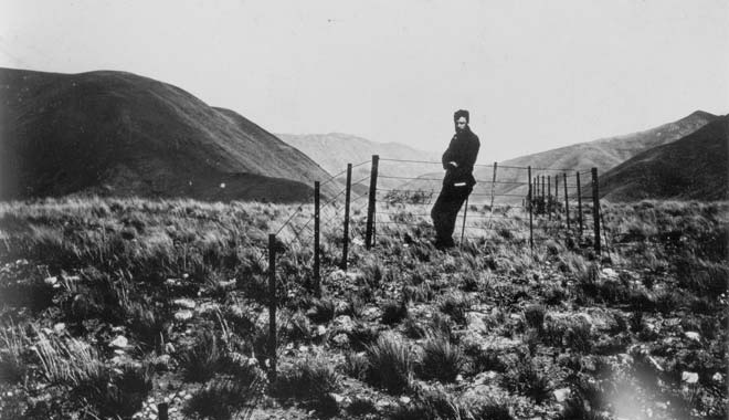
Young Alexander McKay on the Hope fault at Glynn Wye after the 1888 earthquake; he rightly interpreted the uplift and dextral lateral movement shown by the offset fenceline. The surface break runs from L to R across the photo; McKay stands on the high side.
Alexander McKay was a self-taught geologist and a careful and diligent observer, missing little he saw. We have come across some of his work previously – e.g. the Moa-bone cave at Redcliffs, Christchurch.
- Cross Hanmer River bridge and climb through Triassic/Jurassic greywacke to cross the gorge on the one-way steel Waiau Ferry Bridge. The Waiau River takes its name from the Maori for “swirling currents”.
- Take care, and immediately after the bridge, following signs on your left, drive into the Hanmer Jet premises and park appropriately in the area to the right.
- Walk a short distance towards the Office, ascending by the steps of historic timbers (take care – use the handrail) or the ramp, to an area adjacent to the building and beside the fence, from where the bridge, river, gorge and deformed bedded greywacke can be safely viewed.
- Please keep off the verandah and do not enter the foyer/lounge area as Office customers need to use this, unless you wish to purchase food or drink (or take a Jetboat Ride or Bungy Jump – if you are going to attempt the latter, please let us know, as we wish to cheer your courage). Icecreams, soft drinks and snacks may be purchased here. Do not let children wander freely in this area, as a short distance away the gorge edge is unfenced. You may spend up to 20 minutes here. After enjoying the sights (perhaps vowing to return for a Jump or a Jetboat or Raft Ride) return to your Jowetts, exit the premises turning left and continue towards SH7.
- At the Compulsory Stop, turn left to join SH7 signed for Culverden/Christchurch. Take extra care as this is a tourist road and at times will be busy. For the next few miles follow the Waiau through its gorge, stopping safely to enjoy the views and taking a photo or two.
The Waiau River rises in the Spenser Mountains, so-named by William Travers, a Nelson lawyer, politician and naturalist, after the Elizabethan-age poet, Edmund Spenser. Located to the north east of the Lewis Pass and trending towards the Travers and St Arnaud Ranges and Wairau Valley, its highest peaks are the Faerie Queene 2,237 m (7,340 ft) and Mt Una 2,300 m (7,546 ft), peaks named from Edmund Spenser’s best known poem “The Faerie Queene”. The Waiau Gorge is the first of three gorges the river has cut before it finally reaches the sea north east of Cheviot; its second gorge is through the Lowry Peaks Range downstream of Waiau township and the third through the coastal Hawkswood Range, downstream of Spotswood/Parnassus; only the first gorge can be followed and viewed from a public road.
- Part way through the gorge a vineyard appears on your left – Waiau River Estate – stop here to view the plantings and the quarry ahead. Currently not operating, the vineyard is up for sale, should you wish to acquire a millstone attached to some 50 acres of Canterbury high country. The Estate previously offered wines under the labels “Marble Point” and “Hell’s Gate”, in varieties such as sauvignon blanc, riesling and pinot noir; they may be difficult to source nowadays as the Marble Point Winery went into liquidation in June 2017.
- Down the straight from the vineyard gate you can see a small quarry in reddish-brown rock, differing significantly from the surrounding greywacke. This early Tertiary (Eocene) limestone has spasmodically been quarried here, generally for limited use in or around Christchurch as a decorative stone. It lacks the usual Amuri Limestone’s white or creamy colour due to the presence of red volcanic ash in the limestone; at the time of limestone deposition, volcanism was occuring in many parts of North Canterbury, hence the discoloration. Commonly referred to as a marble due to the mottled colour, it is not a true marble, showing little or no signs of re-crystallisation.
- Proceed with care; after passing the quarry the bed of limestone can be seen down in the river bed to your left and on the other bank, but stop with care to do so. Also, observe the many river-cut terraces at many levels through the gorge; these were formed over time as the river down-cut through the rising mountains.
- Continue through the gorge but take care approaching the plain, as there is an unsigned left turn coming. After crossing Stinking Stream the gorge begins to open out and a yellow/black roadsign indicates an 85 kph right hand bend; after this bend another road sign indicates a side road to the left – this is the unsigned Leslie Hills Road – there is a sign for Greenwood Sheds on the other side of SH7. Turn left into Leslie Hills Road and proceed to cross the bridge and park safely on the left beyond the bridge amongst the pines.
- Leave your car to view the bridge and the water intake below the bridge.
Note also the abundance of greywacke rocks in the river – these are the remnant of the mountains through which the gorge has been cut, before the river spreads out across the plain in braided stream fashion. Take care and do not allow youngsters (or the more mature) to fall from the bank or bridge; this is the Waiau Intake for the Montrose Irrigation System, a part of the Amuri Irrigation Company’s project for the Culverden Basin. More details taken from the company’s website follow.
Amuri Irrigation Company; Irrigation Scheme for the Culverden Basin.
The project involves three schemes: the Balmoral Scheme in the west, the Waiau (or Montrose) Scheme in the central north, and the Waiareka Scheme in the north east (see map following).

Map of Irrigation Scheme, Culverden Basin (Culverden marked centre, Waiau Intake marked top).
Infrastructure
AIC currently irrigates 28,000 hectares of land within the Waiau and Hurunui Catchments. Our three schemes are composed of open channel and a pressurised pipe network to allow for continuous supply for spray irrigation. Four thousand hectares of land is irrigated from the open race and 24,000 hectares is irrigated via the pipe network. The water taken from the Waiau River is deemed to be highly reliable (99%) whereas the Hurunui River only offers good reliability (95%). Reliability is measured as the amount of time during the irrigation season that water will be available, averaged over the years of the record (this does not consider irrigation demand).
Balmoral Scheme
This scheme was built in 1985 and partially upgraded to pipe in 2017. The consent allows for five cubic metres per second of water to be taken. Water is diverted from the Hurunui River below the Mandamus confluence into a diversion race on the north bank. The water then runs along a race to a control gate structure and into a settlement pond. Any surplus water can be returned to the river at this point. A fish screen and intake are located at the head of this pond and the rate of flow into the intake is controlled by a radial gate at the river intake and a second gate at the head of the pond. An open race carries the water to near Balmoral Station Road where it enters two pipelines for further distribution towards farmland near Culverden.
Waiau Scheme
This scheme is AIC’s largest scheme, the original open race system having been completed in 1980 and partially upgraded to pipe in 2017. It takes 11 cubic metres per second of water from the Waiau River at the Leslie Hills Road bridge, which is then gravity fed along an open race at Mouse Point where it enters the pipe network and is distributed along three main pipelines to farmland closer to the townships of Culverden and Rotherham. The scheme was originally set up for border dyke irrigation but now 100% of irrigation within this scheme is by spray irrigation.
Waiareka Scheme
The Waiareka scheme was opened in 1976 and takes 450 litres per second of water from the north side of the Waiau River at an intake point east of the Waiau township. Water is fed into a settling pond with two fish bypass races adjacent to the fish screen leading back to the river. There are two discharge points for unused water towards the bottom of the scheme. This scheme waters over 400 hectares on eight farms by border dyke and spray irrigation from a single flowrace on a 12-day rotation. In 2018 a 5km pipe and pond was installed to facilitate the conversion to spray irrigation.
Location of Pipe Assets
Our pipe network was completed in 2017 and it is easy to forget where pipe was laid. It is critical that contractors know where AIC’s pipe is buried and that a safe offset distance is maintained when working at depth within the vicinity of any scheme pipework. A damage repair job on larger GRP pipe will cost well into tens of thousands of dollars and these costs would need to be recovered by AIC. Taking into account time to drain lines, repair and refill pipes, it would likely take a week or more. If this coincided with high water demand the downtime would have a heavy impact on potentially many farms.
We have a map file compatible with Google Earth that shows the as-built alignments of the installed pipelines. Note that while the pipe alignments are survey accurate, the aerial photography on Google Earth can be out by a few metres. The accuracy of a cellphone GPS receiver may also be out by a few metres. For these reasons, if you need to know the exact location of an AIC pipeline, one of our staff can more accurately locate and mark the pipeline alignment with our survey equipment. We are also signed up to BeforeUDig, an online system that is commonly used by contractors to obtain information on the location of cables, pipes and other utility assets in and around any proposed dig site.
So now you know all about the irrigation scheme in the Culverden Basin.
- From viewing the Waiau Intake, return to your Jowett and recross the bridge to return to SH7, turning left signed for Culverden 13kms.
- A mile ahead stop carefully on the left opposite Montrose Road, adjacent to Bridge 520, Montrose Irrigation Race. Here view the race which goes underground at Mouse Point, into the piped system, about which you have read.
- After viewing the Montrose race, continue ahead 2 ½ miles and turn left into the Flintoft Mouse Point Road, signed for Waiau/Kaikoura; the road name is not signed but a short distance ahead is an electricity sub-station.
- The name Mouse Point is applied to the ridge-end knoll rising just to the west of SH7 at the intersection of Flintoft Mouse Point Road; this is said to have come from the time a plague of mice infested the area – it may also have come from the mouse-like shape of the ridge end?
- Just after passing the sub-station and pylons, if the day is clear, stop safely as you may have a fine though distant view to the north east of Mt Tapuaenuku, the highest peak in the inland Kaikoura Range at 2,885 metres (9,465 ft).
This was sighted by Captain James Cook in February 1770 and he described it as, “a prodigious high mountain”. It often stands out as a splendid peak from the ferry when crossing Cook Strait in good weather. The first Europeans to climb the peak on the 13th November 1849, were William Hamilton, survey officer on the survey vessel HMS Acheron and Edward Eyre, an Englishman who had explored and administered in Australia, then became Lieutenant Governor of New Munster in the colony of New Zealand, before becoming Governor of Jamaica. Established in 1846, the province of New Munster was effectively the South Island and Wellington, however it was abolished in 1853 to become the provinces of Wellington, Nelson, Canterbury and Otago.
- Continue on Flintoft/Mouse Point Road and at the giveway, turn left onto the Rotherham South Road SH70.
- You may be aware that a rail line once served this district, the branch line through Waipara and Waikari reaching Culverden in 1886, however the Waiau Branch to Rotherham and Waiau was not opened until 1919; the line was closed on 15th January 1978. Little remains to show rail once served the district (the track formation is occasionally seen beside the main road) however the inner section, Waipara to Waikari, remains in use as the Weka Pass Railway, run by a Trust and delighting the public regularly.
- After Leaches Road on your right, stop by the tall gums on the left at number 689 thats us! There is a bus shelter adjacent to the letter box and a gravel drive leads some distance up to the unimpressive rear of a large residence. This is now Amuri Manor with an impressive frontage but once it was the Amuri Hospital.
Amuri County Hospital, Rotherham.
This large residence, currently just finishing a significant restoration, was once the North Canterbury Hospital Board’s Amuri Hospital. A need for small country hospitals was recognised in the aftermath of the 1918 influenza epidemic, which killed many thousands throughout New Zealand. Some nine acres of land were obtained on the outskirts of Rotherham and plans for a “Cottage Hospital” were prepared by the architects Collins and Harman; the hospital was to serve the maternity and medical needs of the surrounding Amuri County. These plans were approved by the Board in August 1919 and soon after, a tender of £7,700 from Mr J Taylor, was approved for construction in concrete, plaster walls and poilite roofing. The Minister gave consent for the building in March 1920 and the Board of Trade permit was issued in June. District residents donated £1,652-19-0 in 1921 and in spite of material shortages and cost increases, the modern building was opened in January 1922. It had 15 rooms, 5 bathrooms and 2 kitchens. The Nursing Division director, Miss H McLean, appointed Miss C Blackie as Matron and the hospital was operating. With our current knowledge and technology, why can’t a hospital be built that quickly nowadays?
In 1922, a doctor’s house was obtained with £740 of local money, however this attractive home was destroyed by fire in 1936 and a replacement was planned, in concrete. By 1925 it was realised that the hospital was serving relatively few maternity cases and instead of local needs, was being used primarily for convalescence of patients from Christchurch Public Hospital. By 1931, with the depression affecting the country, the Board recognised that the Amuri Hospital had been over-built for the surrounding needs and being isolated it was difficult to staff with high calibre professionals; finances also at this time were limited. Nonetheless most of the money for construction had come from the district and the Board could do little but continue, knowing well that although Country Hospitals were now difficult to justify, there was strong opposition to closures.
Amuri Hospital was eventually closed in 1960 and medical services in the district are now managed from Medical Centres. The building was sold and has been converted to a large residence, though many facets of the hospital remained for many years. The current owners are continuing the restoration of the property (begun by earlier owners) to a high standard, this work nearing completion; it will offer some accommodation and the grounds are expected to be impressive.
Continue a short distance towards Rotherham and turn right into South Street, parking safely on the left adjacent to the historic Watters Cob Cottage.
Watters Cob Cottage, Rotherham.
Read the information board and walk around the building admiring the tenacity of early settlers who came to work, build, live and raise a family in what then was an extremely isolated situation, supported initially as part of the Nelson province.
- From the Cob Cottage, continue on South Street and turn left into Wilkin Street.
- Pass the rear of Rotherham School established in 1883.
- At the intersection with Heaton Street, note St Mary’s Church ahead to the right.
Turn left into Heaton Street and park near the Rotherham Store and Post Office. - Rotherham Store and Post Office. This is one of the oldest country stores still in operation in New Zealand and unfortunately closed on Sundays. For information read the historic plaque opposite, on the village green; there are also toilets here.
- Take a short walk around the corner where you can read the information at St Mary’s Church entrance – if parishioners are still taking morning tea on the lawn after service, you may be able to enter the church and examine the special stained glass windows.
- From the Rotherham Store continue to the giveway at the main road intersection (the hotel is here) and turn right onto Rotherham North Road SH70, signed for Waiau 10 kms.
After leaving Rotherham, note the unusual ridge beside the road on your right, exposing yellow-brown mid-Tertiary calcareous sand- and siltstone; beyond the ridge lie older lower Tertiary and uppermost Cretaceous sediments together with some older uplifted greywacke. The Culverden Basin is surrounded by rising greywacke mountains and in many places around and occasionally within the basin are these remnant outcrops of the Cretaceous-Tertiary sediments that once, before mountain-building began, covered and concealed the greywacke but now have been uplifted with the greywacke. Some of these interesting basin-margin outcrops occur at and beyond Waiau, at Pahau Downs, at Island Hills, at Pyramid Valley/Waikari and at McDonald Downs, for the basin extends from beyond Waiau in the northeast to the Upper Waipara Gorge in the south west.
- Pass the Amuri Golf Club and Helipad on the left; once a golfer needed only a ball and a stick.
- Cross the Waiau River (two passing bays on the bridge).
- From the bridge enter the township of Waiau on Lyndon Street.
- At the village green, turn left onto Cheviot Street and park adjacent to the green or the Community Hall.
- Here in the hall you can take lunch with hot water and toilets available. History on the Green. Museum, cottage and church and learn a little of their history.
- After this, take the opportunity to follow parts of the Waiau Historical Trail, either on foot or by car or a combination. Use the two following information pages to follow this Trail.
- The stone Anglican Church (now owned privately – Anglicans are served by St Mary’s at Rotherham) is constructed of a variety of local river boulders; see how many different lithologies are present.

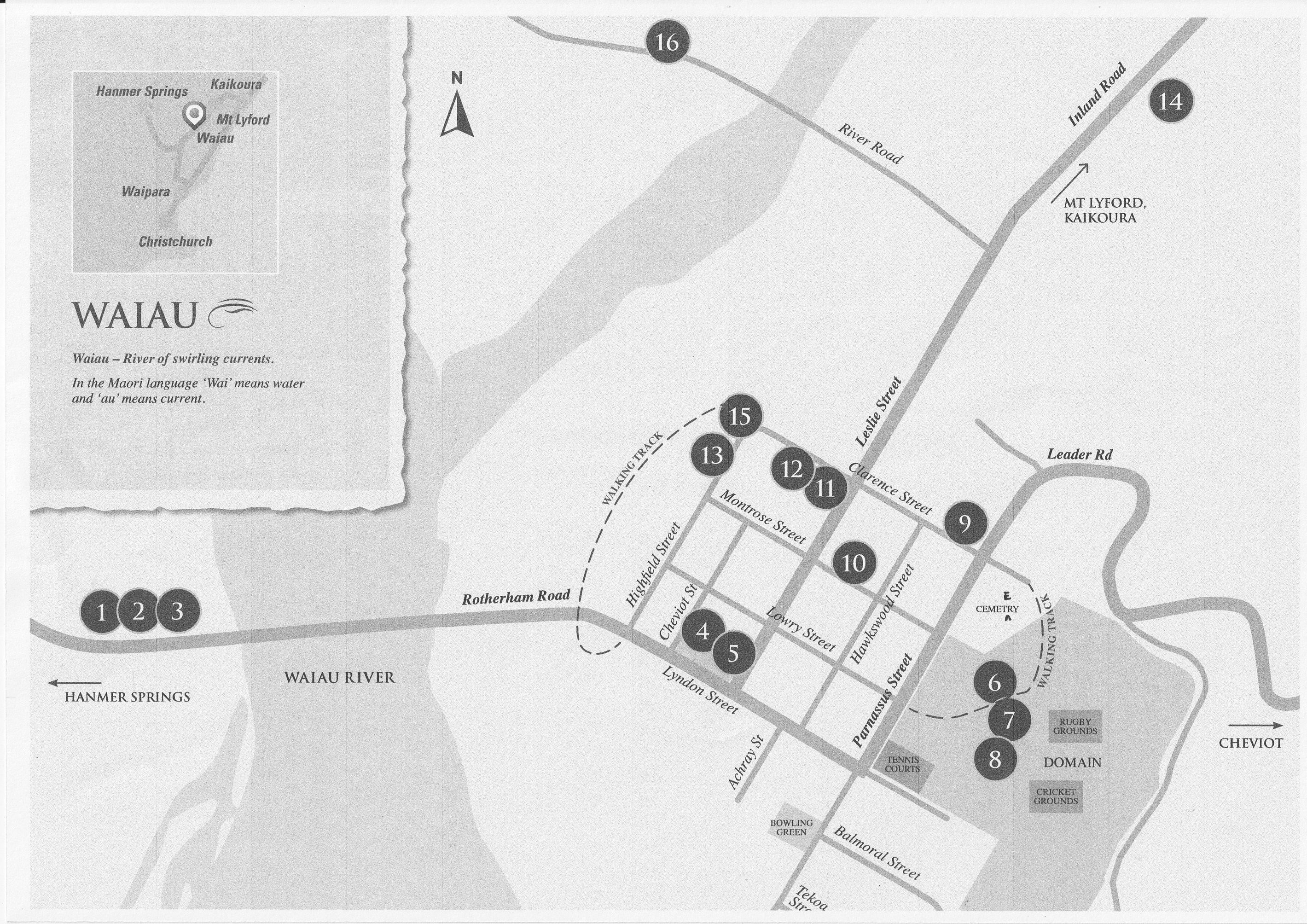
Look especially in the cemetery for the grave of well-known farmer, car driver and collector, Duncan Rutherford; his retirement car collection in Nelson was much visited but has now largely been dispersed. Duncan farmed nearby at Leslie Hills and was notorious for regularly driving his beloved Darracq veteran car in to Christchurch and back the same day for a rally, accompanied by his dog sitting up beside him.
Optional Visit to Mt Lyford Village.
Should you wish, you could now take a scenic drive north on the Inland Highway SH70 to pass Rodin Cars (part of the track can be seen from the roadside but visitor access to Rodin Cars is closed at present) to reach Mt Lyford Forest Road on your left, and sight the Mt Lyford Lodge, claimed to be the largest log cabin building in the country, and then drive up the Forest Drive towards the skifield, through the collection of holiday cottages which comprise Mt Lyford Village;.
There are no shops at Mt Lyford. Be sure to have some warm clothing as on a recent visit it was snowing heavily and the road called for care. Roads in the Village are private roads so exercise caution; it is possible to follow the main route through and the side roads, which loop back and forth.
From Waiau to Mt Lyford Lodge is about 12 miles, with a further three miles up to the village, making the round trip back to Waiau about 30 miles; it is unlikely the skifield will be accessible to our cars and in bad weather even the village on the slopes of Mt Lyford, calls for 4WD vehicles.
Route instructions for this visit are given below, after the little story about Waiau. Please let Ramon Farmer know if you are going on this Optional Visit.
Meanwhile, a little story about Waiau – the Forgotten Earthquake Town?
In North Canterbury, a 7.8 magnitude earthquake occurred at 12:02 am on 14th November 2016, with its epicentre at 15 kms depth, about 3 miles east of Rotherham and 3 miles south of Waiau. This turned out to be the most complex ‘quake ever recorded with modern instrumentation, as the initial break spread northward through a series of faults – more than twenty were involved. As we felt it in Christchurch, the first arrivals were strong but felt to be the usual early arrivals, however after a few seconds other arrivals confused matters and the shaking of our house in Hoon Hay became quite complex, juddering, rolling and bouncing on for some two minutes (the 2010 Darfield ‘quake was about only 50 seconds). At the time most folk probably thought it must be coming from the Alpine Fault, but this was not so; a simple, relatively small fault near Rotherham/Waiau had broken, but this was followed by a break on an adjacent fault a few kilometres away, then another and another, and so on, all the way to and beyond Kekerengu and then offshore and into the southern part of Cook Strait. The onshore extent of these breaks followed mapped and previously unmapped faults and exceeded 160 kms and marine surveys later traced the offshore continuation on other faults. Large sections of the Kaikoura coastline were uplifted, some up to 10 metres. A tsunami over 6 metres high was recorded near Kaikoura and on tide gauges at three other locations on the east coast of North and South Islands. Onshore surveys immediately after the ‘quake showed widespread lateral movements of between 6 and 10 metres and modelling has shown some faults had up to 20 metres slip at depths of 10 to 15 kms. Landslides were everywhere; some 10,000 were recorded, destroying roads, railway lines and bridges, and damming rivers to form new lakes.
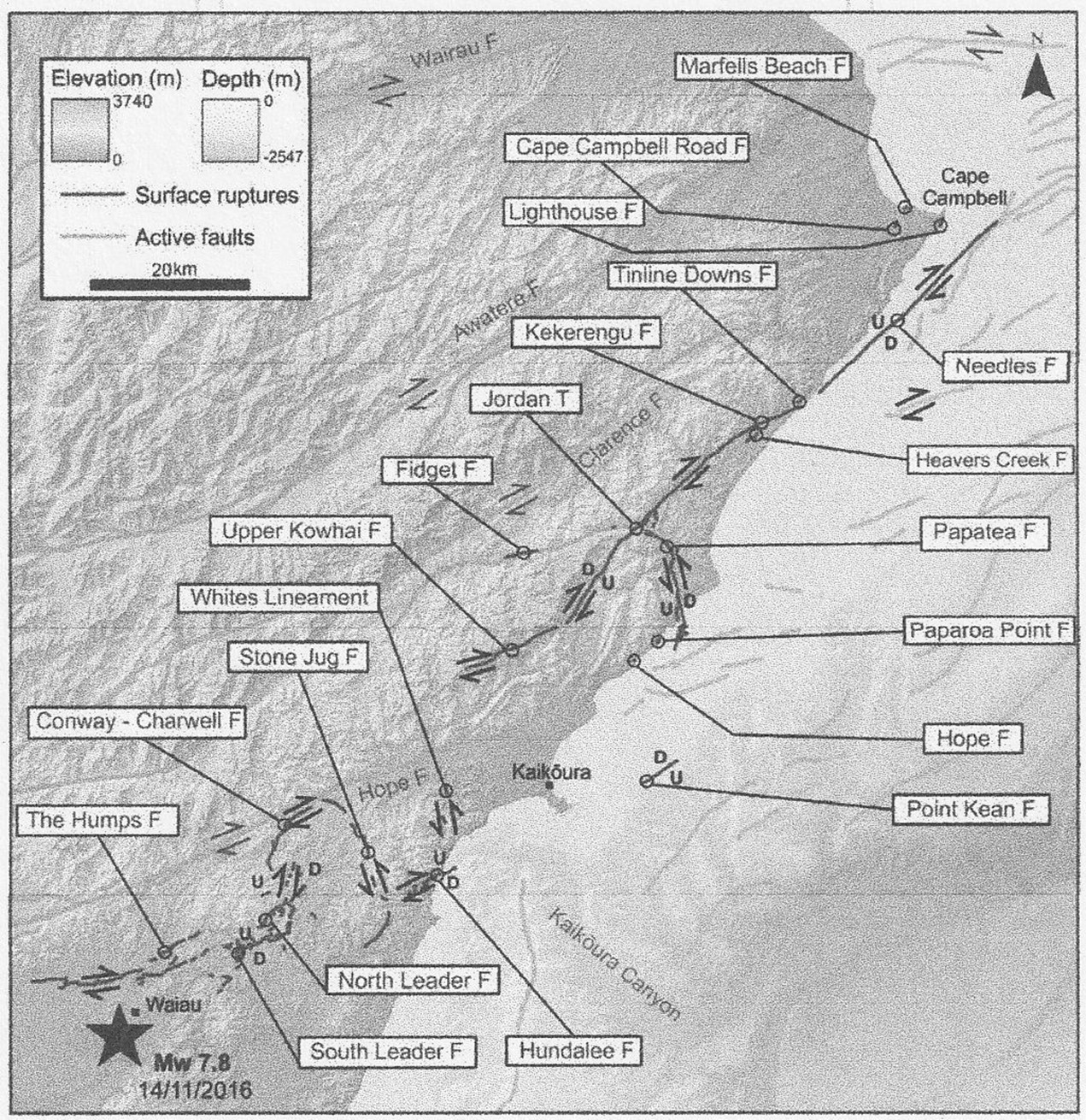
Geonet map of North Canterbury/Marlborough showing many of the faults that successively ruptured on 14th November, 2016. The triggering epicentre is shown as a star near Waiau.
Many buildings in and around Waiau were severely damaged, as indeed happened to others all the way north to Kekerengu. Somehow, in this 160 miles of carnage, only two lives were lost, though there were many minor injuries. One death was in a house near Kaikoura and the other was at Mt Lyford, the latter being Jo-Anne Mackinnon, the partner of Gary Morton, a man some of us know well, as for many years Gary has been the only person in New Zealand able to rebuild wire wheels for old cars and motorcycles, using new spokes from abroad and new rims, made at that time by the late Brian Black in Harman Street, Addington, Christchurch.
In 2000 Gary had moved from Christchurch to live at Mt Lyford, where he had built a lovely log house on the hillside and was able to carry on wheel-building in his adjacent workshop; by now his wheels were not just for local clients but were being sent world-wide. In 2010 Jo came to live at Mt Lyford with Gary and he found her to be a strong and very special person, having gained a university degree later in life she was working as a senior probation officer dealing particularly with high risk offending, requiring her to travel throughout New Zealand. At 12:02 am on 14th November 2016, they had just turned TV off and Gary went to let the dog out when he felt himself thrown up, in his own words, “just like going too fast over the stopbank on McLeans Island Road, Christchurch”. He was thrown through the doorway and at the same time was struck by Jo who was thrown from behind. Outside, he was thrown about on the ground amongst firewood for about two minutes with the violent shaking, but when it settled down he shouted for Jo but received no answer. There had been moonlight before the ‘quake but after, all was black. He started the car and moved it to light the scene and then found Jo – she was in the doorway and had been struck on the side of the head by a large post, one of the supports for the upper floor; it had been wrenched free and struck her sideways, knocking her into his back.
Gary eventually rebuilt the house but understandably, moved away from the district, however a memorial to Jo remains at Mt Lyford. You can read Gary’s traumatic story and the stories of many others in the district, in an excellent book recording individual’s responses to the disaster; its title is “Hurunui Seismic Stories” compiled by Emily Anderson and published by the Amuri Community Arts Council in 2020 – the ISBN is 978-0-473-51123-4.
The media however, focussed on the well-known tourist township of Kaikoura, the loss of the coastal road (SH1) and rail system and the consequent effect on the tourist trade; as a result the quake is commonly referred to as the Kaikoura earthquake – Waiau, Rotherham and Mt Lyford appear to have been forgotten.
This earthquake showed a complex relationship in the strain behaviour of a chain of faults, some of which were separated by over 15 kms; previously it had been thought that strain release on one fault was unlikely to trigger release on another fault nearby – no one expected strain to jump 15 kms and more from one fault to the next. This ‘quake gave us something new, consequently it has been studied extensively by scientists here and overseas and this work will certainly lead to changes in the analysis of earthquakes and in risk prediction for the future. Shades of Alexander McKay and the 1888 Glynn Wye fenceline!
Optional Run from Waiau to Mt Lyford Lodge/Village and return, approximately 30 miles.
- From Cheviot Street beside the village green in Waiau, turn left onto Lyndon Street, then first left onto Leslie Street following signs for the Inland Road SH70 for Mt Lyford/Kaikoura.
- Pass Sawmill Corner and River Road to your left.
- Cross the Mason River (one way bridge).
- Veer right to pass Sherwood Road on your left.
- Cross the Lottery River (one way bridge).
- As you climb away from the Lottery beware the tight left-hander, known as The Tongue; it has landed a few people in trouble, on the way up and on the way down.
- Near Wandleholm Station, again beware more left handers as you descend to cross the Wandle, and then again, ascend; these river cuttings in soft mid-Tertiary mud- and siltstone, were formed relatively recently and create stunning scenery but the short steep climbs create tight bends.
- After emerging from the Wandles, note the attractive grassed area to your left; note too that it has a protective Armco steel barrier a short distance in from the fence, extending alongside the main road for about a kilometre.
Rodin
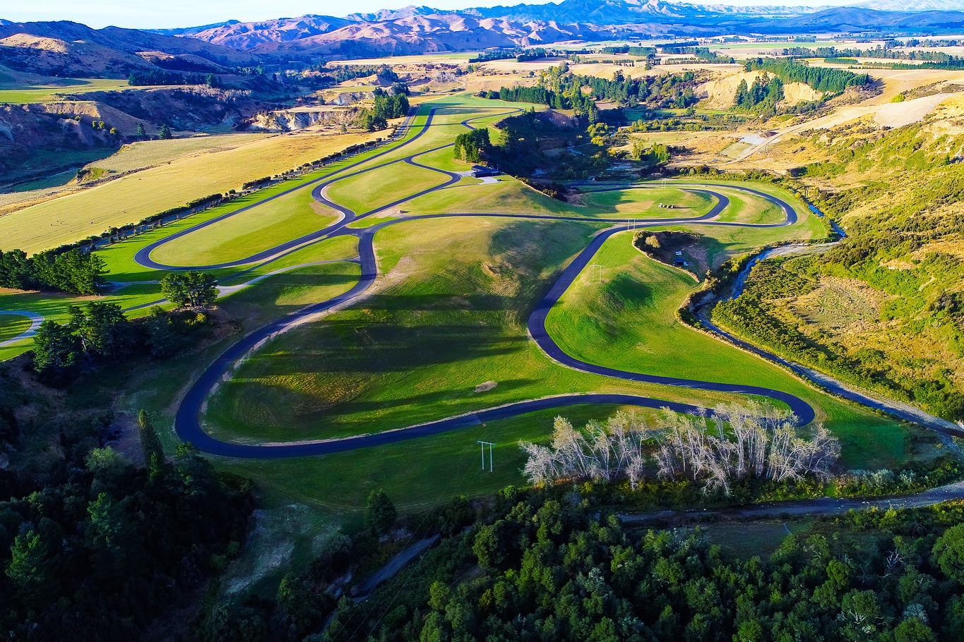
This is the private Rodin Test Facility for Rodin development and for owners (and prospective owners) of the high speed, high tech Rodin performance cars; the works where they are developed and built lie just a short distance ahead. There are actually three tracks here; a 200 metre skid pan near the works, a roller coaster twisting 2.35 kms test track along the valley side with 12 bends and 53 metres of rise and fall, and a fast flat 2.44 kms circuit on the terrace top with a 900 metres straight where speeds up to 300 kph are reached. Most of this latter track is adjacent to the main road.
A little further ahead, behind the white rail fence and impressive gates on your left is the home of David Dickers, who after succeeding in IT business, indulges in his favourite relaxation here – going for a very fast adrenalin-packed ride in his own-designed and -built very fast cars. His aim was to create a car that would be faster than a Formula One car, without the F1 restrictions – he appears to have done it. He utilises every high tech aspect in developing the cars including carbon fibre and titanium printers – he has one of the largest titanium printers in the world – and he now is entering the top levels of motor racing in a venture with Red Bull. David has two current offerings for purchase, the first being the FZED, an open-wheeler track car which starts where Lotus left off; it produces 675 bhp at 9,200 rpm, weighs 609 kgs (wet) and will do 300 kph. The second is the F Zero, a 4.0 litre V10 petrol-engined hybrid which produces 1013 bhp at 9,500 rpm coupled with a 174 bhp electric motor driving the rear wheels; the F Zero will do 360 kph (224 mph!).
- Drive quietly onwards, enjoying the half-tamed scenery in this peaceful valley.
- Pass Terako Downs Station on the left, and soon after pass Mason Hills Station on the right, opposite Snowdon Road.
A short distance ahead the bed of the Mason River can be seen adjacent to the road; it is choked with erosion debris – boulders, cobbles, gravel, sand and silt – and regular floods spread this over the road SH70. Some of the 10,000 landslides which accompanied the 2016 earthquake brought this down from the rapidly rising mountains hereabouts and heavy rains keep it moving; this process cannot be stopped.
- At Mt Lyford Forest Hills Drive on your left, turn in and park to admire the largest log cabin in New Zealand. The Mt Lyford Lodge is now owned by Rodin Cars and though offering accomodation and meals for guests, its hours are limited and it offers little for passing motorists or casual visitors such as Jowetteers.
- From the Lodge proceed up the Forest Hills Drive. In the actual village roads are private but you can follow Mt Lyford Avenue through the village with a loop road to the left (Tinline Terrace) and another loop, Lulu’s Lane/Terako Terrace to the right, allowing a view of the many holiday homes. Most users are keen skiers or hunters and thrive in the outdoors, however we are on the slopes of a mountain and the upper homes are about 2,500 feet above sea level (nearly the height of Banks Peninsula’s Mt Herbert) so expect it to be a little parky in poor weather. You should not go beyond the village on the skifield access road.
- Return to the Lodge and SH70, turning right to wend your way back to Waiau where you may need refreshment at the tearooms or possibly take tea at the Rotherham Hotel.
Homeward Journey from Waiau to Hanmer Springs.
You have two options:
To return the way you came, via Rotherham (the hotel may suit for afternoon tea), Mouse Point, the Waiau Gorge and the Waiau Ferry Bridge.
Or for those seeking a different route with a short unsealed section:
- Follow Leslie Street SH70 north out of Waiau and at Sawmill Corner turn left onto River Road.
- Follow River Road for three miles before turning right onto Leslie Hills Road.
- Stay on Leslie Hills Road, and pass Mt Paul Road; a short section here is unsealed.
- Pass the Druids Station and Morses Road on your right then cross Emu Plains.
- Return to the seal and pass Leslie Hills Station; this was the home of Duncan Rutherford, “Car Enthusiast” and probably known to many. Rutherfords still farm in the district.
- Pass Morna Downs Station and soon after, reach the bridge and water intake for the Montrose (Waiau) Irrigation scheme.
- Cross the bridge, turning right onto SH7 heading for Waiau Gorge, Waiau Ferry Bridge and Hanmer Springs.
Either way, have a safe journey and we hope you enjoyed the outing.
